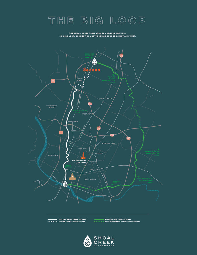
The Big Loop is a 30-mile connected trail system north of the Colorado River and the Shoal Creek Trail is the 11-mile western link within it.
Once gaps between the major trails are reconciled, the Big Loop will allow Austinites to walk, run, or bike from the Butler Trail at Lady Bird Lake north to the Northern Walnut Creek Trail at the Domain by way of the Shoal Creek Trail and Red Line Trail, then head southeast to the Southern Walnut Creek Trail and back downtown along the Lance Armstrong Bikeway. The 30-mile loop will eventually frame an urban trail network that connects to numerous other existing or proposed trails within Austin and beyond.
Read why The Big Loop is so important
As of September 2024, all sections of the Big Loop trail connections are in development, whether they are being studied, designed or constructed. The progress of projects in each trail section was presented by the the Sidewalks and Urban Trails Division Manager at the September 2024 Austin City Council Mobility Committee meeting and can be viewed in the link below.
City’s Big Loop Update – Sept 2024
Shoal Creek Trail Southern Terminus
The southern end of the Shoal Creek Trail currently connects to the Lance Armstrong Bikeway on 3rd Street as well as to the Ann & Roy Butler Hike and Bike Trail south of W Cesar Chavez Street. While the connection to the south end of the Big Loop does exist, ambitious plans are in work to improve safety, access and connectivity for people on foot and bike in the area around Shoal Creek and 3rd Street.
Shoal Creek Trail Northern Terminus
The northern terminus of the Shoal Creek Trail is currently just north of US Hwy 183, but without a clear and safe connection to the Red Line Trail and the Northern Walnut Creek Trail. The envisioned Big Loop aims to close that gap.
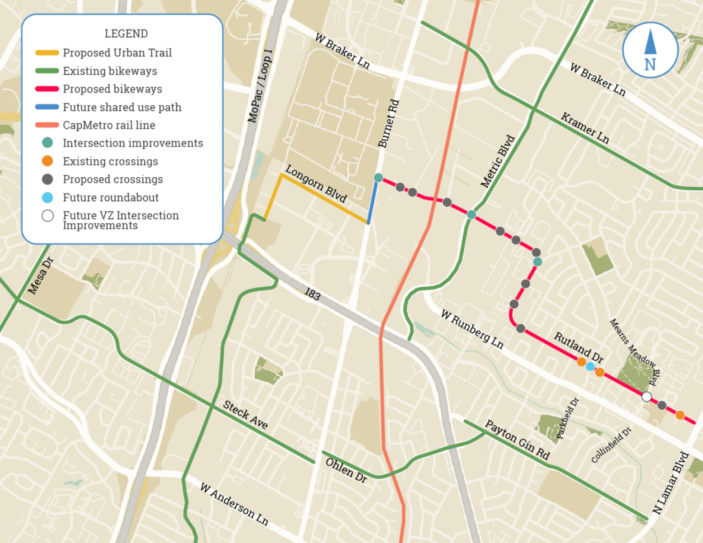
In September 2024 the Austin Transportation and Public Works Department collected feedback from the community on their safety and mobility project on Rutland Drive, Longhorn Blvd and Neils Thompson Drive in north Austin. The plan proposes to extend the Shoal Creek Trail by 0.7 miles and helps to close the gap between the Shoal Creek Trail and the Red Line Trail! Click the map below for a closer look at the proposed project area.

Read SCC’s comments on the Rutland Drive Project
Learn more about the City’s Rutland Drive Project
On October 18, 2024 the city’s project team announced that, in response to the feedback received, they are moving forward with the planned design, which includes a concrete urban trail on the west side of Neils Thompson Drive and the north side of Longhorn Blvd with separation between people walking and bicycling. Construction along Rutland Drive will begin late 2024 and construction on the urban trail extension will occur spring 2025.
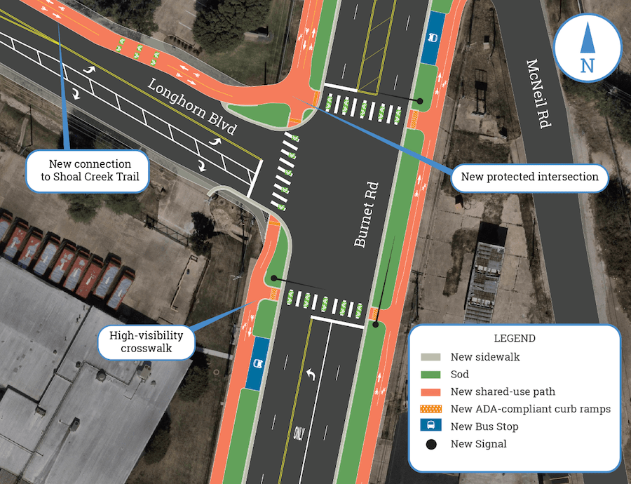
On April 21, 2025 the City of Austin announced that they began construction on the extension of the Shoal Creek Trail that will connect the trail from the US Hwy 183 frontage road to Burnet Road! The City recently completed the first phase of improvements along Rutland Drive between Burnet Road and North Lamar Blvd to provide protected bike lanes, new pedestrian crossings and intersection safety improvements. The next phase of the Rutland Drive Project is to construct the new Shoal Creek Trail extension along Longhorn Blvd. Then, following the trail work, the final phase will construct intersection improvements and a shared use pathway along Burnet Road, connecting Longhorn Blvd with Rutland Drive. Click the map below for a closer look at the planned intersection improvements.

Back to Projects
