City’s 24th-34th Shoal Creek Trail Gaps Project Plan
March 13, 2024 | By Shoal Creek Conservancy
The City of Austin’s Transportation and Public Works Department has published the results of its community engagement survey for the Connectivity Gaps project on the Shoal Creek Trail from W 24th Street to W 34th Street.
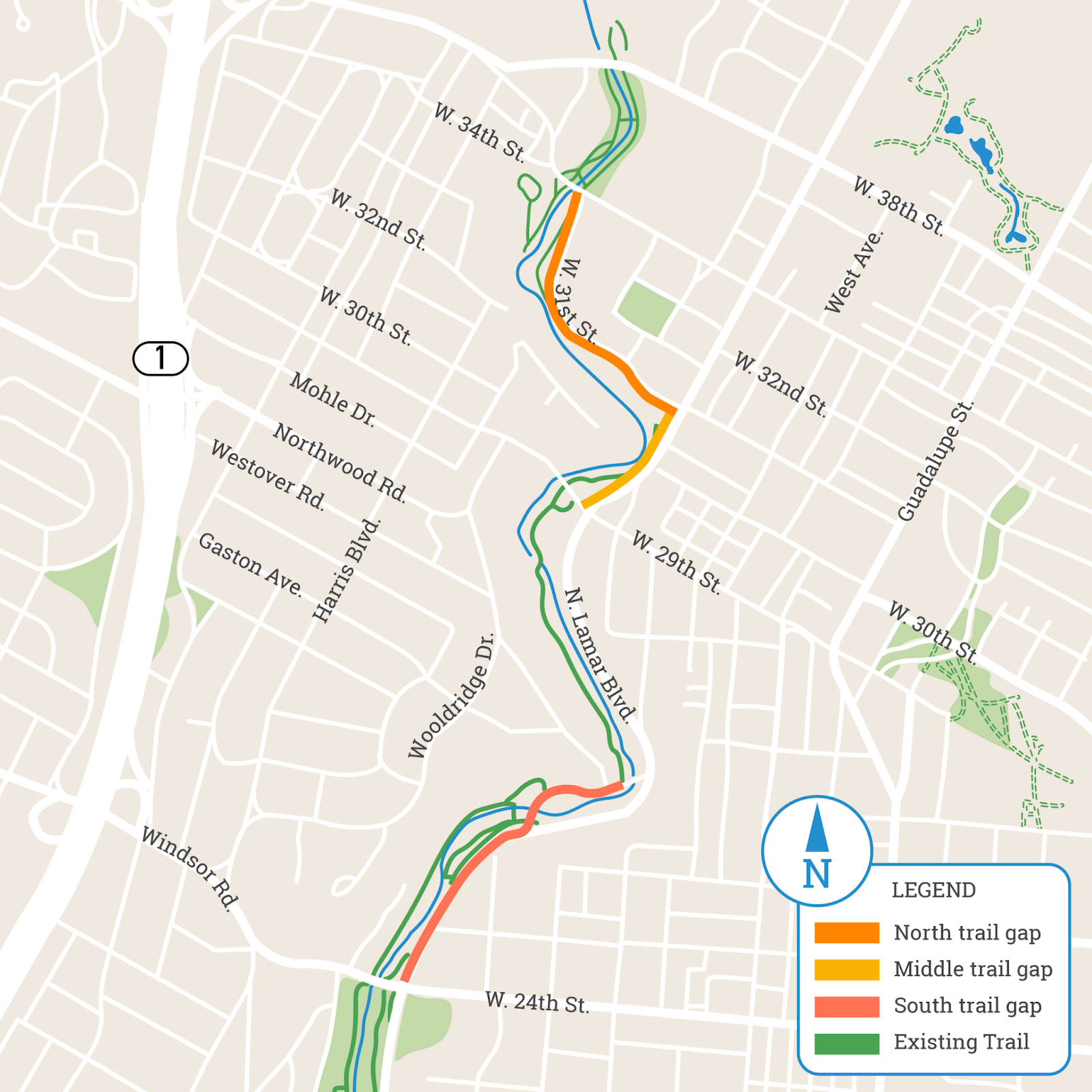
This project is broken down into 3 segments: South, Middle and North. The project addresses major connectivity gaps in the 11-mile Shoal Creek Trail and solutions that will greatly improve the user experience of the trail.
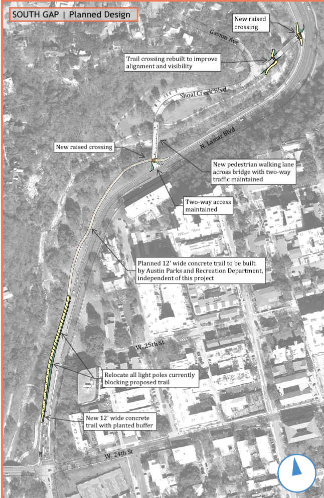
The South Gap Project (as shown above) will install a 12-foot wide urban trail along the west side of N Lamar Blvd and connect the W 24th Street underpass to the Shoal Creek Blvd parking lot and dog park. The design also includes improved street crossings and a walking lane along the north side of the southern bridge into the parking lot.
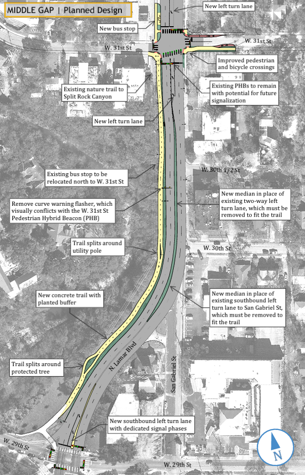
The Middle Gap Project (as shown above) will also install a 12-foot wide urban trail along the west side of N Lamar Blvd and include traffic safety improvements on the street, including intersection improvements at Lamar and W 31st Street, Lamar and San Gabriel, and Lamar and W 29th Street.
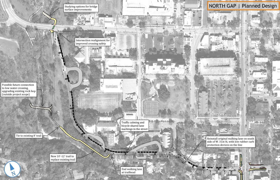
The North Gap Project (as shown above) stretches along W 31st Street between N Lamar Blvd and W 34th Street. It is broken down into two segments: the East segment and the West segment. The East Segment describes the section of W 31st Street between the trailhead at N Lamar and the trailhead located halfway through W 31st Street (across from St. Andrews School). The West Segment describes the section from the trailhead in the middle of W 31st Street heading north to the intersection with W 34th Street.
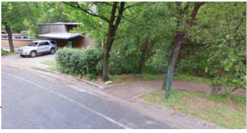
At the time of the creation of the community-guided Shoal Creek Trail Plan, there was an informal and unprotected walking path on the south side of W 31st Street between N Lamar Blvd and the Shoal Creek Trail trailhead (pictured in the middle and bottom photos below). In May 2021, with support from Shoal Creek Conservancy and other stakeholders, the Transportation Public Works (TPW) Department installed a pilot project of a shared use path on the south side of W 31st Street, for the entire length of the street, with protective flex posts and street buttons that separated bikes and pedestrians from car lanes. This pilot project connected the two previously disconnected trailheads and was complementary to the community preferences as outlined in the Shoal Creek Trail Plan.
After receiving feedback during the fall 2023 Shoal Creek Trail Connectivity Gaps Survey, the TPW department has decided to remove this shared use path pilot and replace it with a 6 foot wide walking path that is separated from the car lanes by a low rubber curb. In this new iteration, cyclists will be directed to ride in the street with cars. Shared bike lane markings will be added to the street, and traffic-calming street cushions will be added along the entire length of W 31st Street in the hope of slowing car speeds and creating a safer environment for cars and cyclists in the shared roadway. Shoal Creek Conservancy is disappointed that a solution could not be found at this time to accommodate the car travel and a shared use path along the East Segment of W 31st Street. We are hopeful that a creative solution can be reached in the future that will allow for the 12-foot-wide shared use path on the south side of W 31st Street, as envisioned in the Shoal Creek Trail Plan (see below).
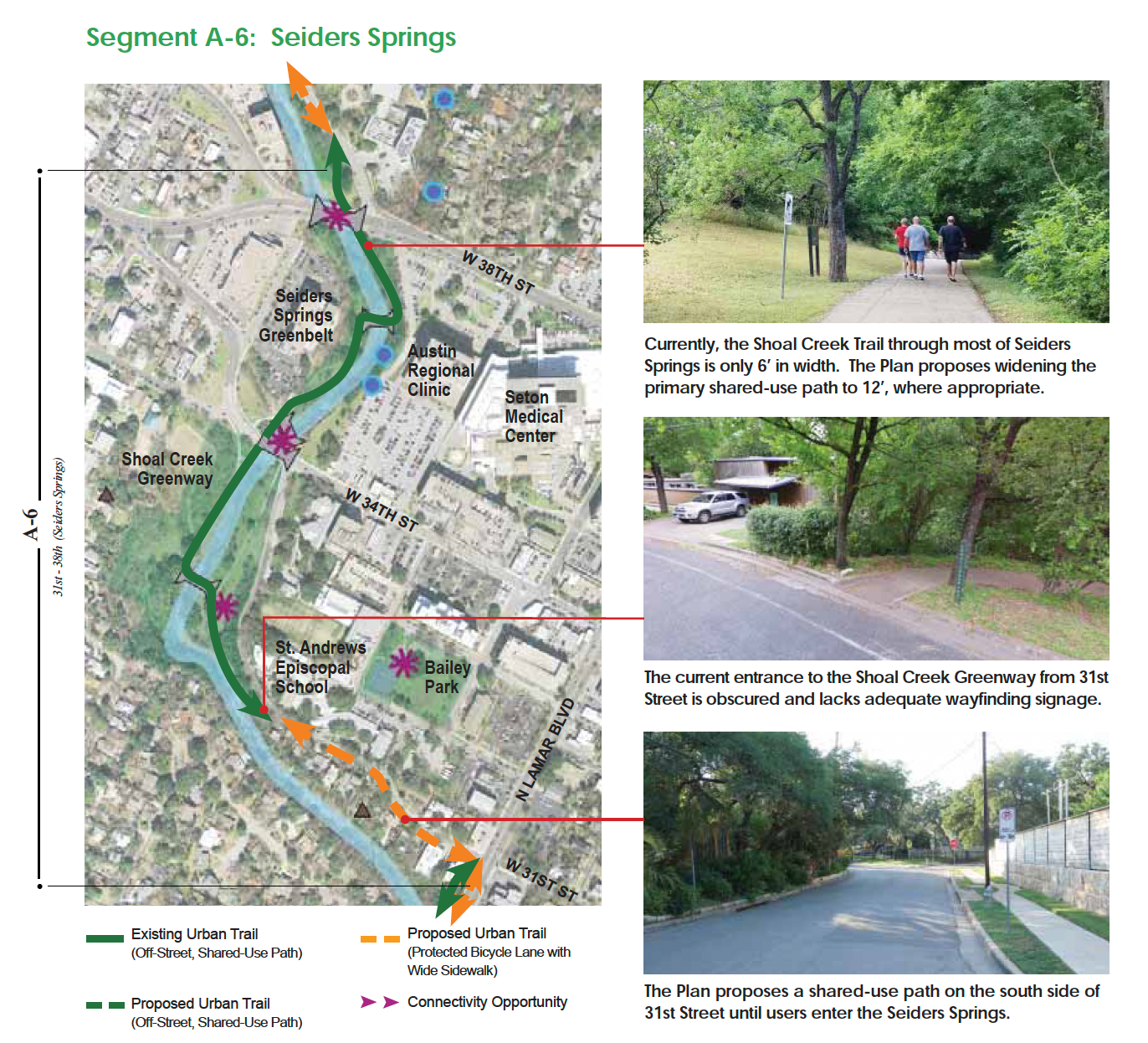
In the West Segment of the North Gap, there is an existing trail that begins halfway down W 31st Street and continues through parkland to the W 34th Street intersection. This is a beloved stretch of trail for users who are able to access it. However, it is currently not accessible to many users due to its steepness. The new TPW project proposes improving the Shoal Creek Trail through this parkland by widening the trail to 12 feet and re-grading the trail, so it will be ADA accessible. This improved, widened trail will stretch from the trailhead on W 31st Street to the Shoal Creek rock hop and gazebo. A preliminary engineering report is to begin soon to ensure the improved trail will not impact any critical environmental features in the area.
In addition to these trail improvements in the parkland, SCC hopes to see improvements to the street-level trailhead in the middle of W 31st Street that will enhance its visibility and make entering the Shoal Creek Trail safer for cyclists coming from the roadway, or students and pedestrians crossing the street from the sidewalk on the opposite side of W 31st Street.
Note: This project does not change the existing rock hop across Shoal Creek. This project also does not widen or change the existing park trail between the rock hop and W 34th Street.
This project will examine the possibility of resurfacing the bridge over Shoal Creek just north of W 34th Street; however, funding for this resurfacing project may or may not be included in the Gaps Project.
Conclusion:
These upgrades largely reflect the community priorities as described in the Shoal Creek Trail Plan. The Shoal Creek Conservancy appreciates the hard work of the City of Austin’s Transportation and Public Works Department to engage the community and deliver high-quality active transportation infrastructure along the Shoal Creek Trail that will allow more people to use this valuable transportation and recreation facility.
Shoal Creek Conservancy will continue to work towards a safer trail connection along W 31st Street and other trail improvements to meet Urban Trail standards along the entirety of the Shoal Creek Trail system.
