Historical Places in the Shoal Creek Watershed
January 18, 2024 | By Shoal Creek Conservancy
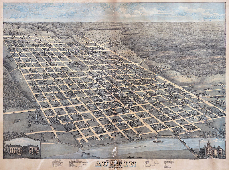
The Shoal Creek watershed has a long and rich history. Native American tribes were known to camp under lush oak trees beside the creek’s cool waters. In 1839, the settlement of Waterloo made Shoal Creek the city’s original western boundary. Not far from the new Republic of Texas capitol, commerce and municipal buildings, and surrounding farmland, residents could enjoy recreational baths in deeper areas of the creek, trek the nation’s first hike-and-bike trail, and travel to the west side of town over the first bridge in Austin which crossed Shoal Creek at Pecan Street.
Shoal Creek Conservancy created a self-guided Audio Walking Tour to bring to life significant cultural spaces and events that have occurred along Shoal Creek’s storied history. After exploring Shoal Creek guided by the Audio Walking Tour and its new signage, check out some other historical places along Shoal Creek and within the watershed.
Shoal Creek Audio Walking Tour Stops, from North to South
- Seiders Springs
- Split Rock Canyon
- Janet Fish Bridge
- 12th Street Bridge
- Wood Street Settlement
- Third Street Trestle
Shoal Creek Audio Walking Tour
Other Historical Places Along Shoal Creek, from North to South
Davis Property, Davis Cemetery & Old Quarry (2705 Twin Oaks Drive)
George Washington Davis received a land grant in 1841 from the Republic of Texas for service in the Texas War for Independence at the Battle of San Jacinto. The land, located where the Spicewood Springs tributary feeds into Shoal Creek, included the Davis home, the Davis Cemetery, and the Old Quarry Site (today’s Northwest District Park), where limestone quarried at this site was hauled to Congress Avenue by oxen and used in constructing the 1853 Texas Capitol Building.
Austin Memorial Park Cemetery (2800 Hancock Drive)
Established in 1927 by a private corporation and purchased by the City of Austin in 1941, Austin Memorial Park Cemetery covers 86 acres in a beautiful setting just west of Shoal Creek.
Pease District Park (1100 Kingsbury Street)
Austin’s first public park, this 84-acre green space with a rich and storied history, is beautifully restored, enhanced, and maintained by Pease Park Conservancy. “From native civilizations evidenced as early as 11,400 years ago, to Edwin Waller’s city map in 1839, to Governor Pease’s donation of land in 1875, to Janet Fish constructing the nation’s first hike-and-bike trail – Pease Park is an integral civic landmark in modern Austin.”
House Park (1301 Shoal Creek Blvd)
In 1903, Colonel Edward M. House, a former diplomat and advisor to Woodrow Wilson, owned the property east of Shoal Creek to West Avenue, from 19th Street (now Martin Luther King, Jr. Blvd) south to 12th Street. He donated that land to the city of Austin for the “benefit of Austin’s youth.” What had been his “horse pasture” now became an area for public use. House Park, an athletic facility and football stadium, opened in 1939 not far from the Rio Grande campus of Austin High School. It was later dedicated to the memory of the Austin High students that lost their lives serving in World War I and World War II.
West Sixth Street Bridge (815 West 6th Street)
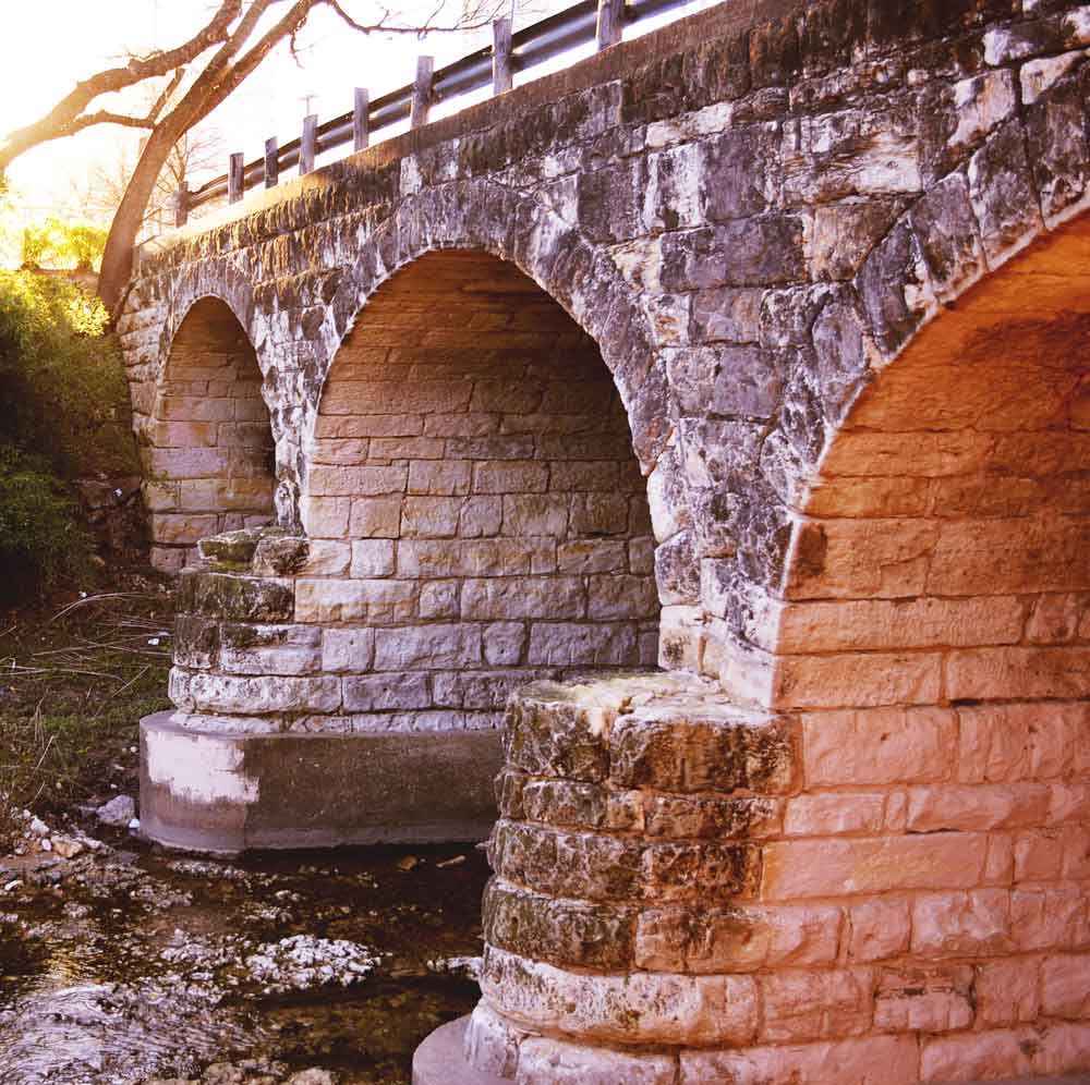
Built by hand in 1887, the triple-arched limestone bridge (historically known as the Pecan Street Bridge) is one of the state’s oldest masonry arches and is located at the site of the first bridge in Austin, which allowed for western development of the city. The bridge predates the Texas Capitol Building and is listed on the National Register of Historic Places and as a City of Austin local historic landmark. Shoal Creek Conservancy is spearheading its rehabilitation and restoration.
More Shoal Creek Bridges, compiled by Ted Lee Eubanks
Margaret Moser Plaza (601 West 3rd Street)
A respected music journalist for the Austin Chronicle and director of the Austin Music Awards, Margaret Moser served on the Austin Music Commission and championed music of all genres. The plaza is dedicated in her honor for her contributions to Austin music and musicians.
Seaholm Power Plant (800 West Cesar Chavez)
A growing population and post-World War II demand for new appliances and air conditioning increased the need for electricity in Austin. In 1948, a new power generation plant was commissioned to be built north of the Colorado River and west of Shoal Creek. In 1960, the city of Austin posthumously dedicated “Power Plant No. 2” to Walter E. Seaholm (1897-1956), who served the city of Austin for 35 years, including as City Manager and Director of Utilities. The Seaholm Power Plant remained an active part of the city’s power generation system until 1989 and the area is now a bustling commercial and residential center in downtown Austin.
Other Historical Places Within the Shoal Creek Watershed, from North to South
Moore-Hancock Farmstead (4811 Sinclair Avenue)
Irish native Martin Moore and his wife, Elizabeth, left their Austin residences and prosperous Pecan Street mercantile business and moved to a farm north of town in about 1850. The Moores farmed, raised livestock, and reared five children here. In 1866 Elizabeth Moore, by then widowed, sold the homestead tract to John Hancock, a prominent local judicial and political figure. Although Hancock never lived on the farm, it is believed that his former slave, Orange, and his family lived here in the late 1860s. John Hancock (for which some Austin roads and landmarks are named) and the freed African-American slaves of the same surname left a lasting legacy in the city of Austin.
Congregation Beth Israel (3901 Shoal Creek Blvd)
In 1876, thirty members of Austin’s Jewish community attended a meeting with the purpose of forming a congregation – not bad for a Jewish community with only 35 families at the time. The Congregation’s President, Henry Hirshfeld, Vice-President, Phineas de Cordova (he and his half-brother, Jacob, are credited with being the first Jews to settle in Austin upon their arrival in 1849), officers and board members selected a site for a synagogue to be built near the intersection of 11th and San Jacinto Streets, near Hirshfeld’s home. Post-Civil War economics slowed its construction, but the building was finished in 1884 and served a growing Jewish community in Austin. In 1947, with a post-World War II rise in membership, Congregation Beth Israel voted to expand the Synagogue’s facilities and purchased a property off of Shoal Creek, where the Congregation continues to reside.
Pemberton Heights Neighborhood (1415 Woolridge Drive)
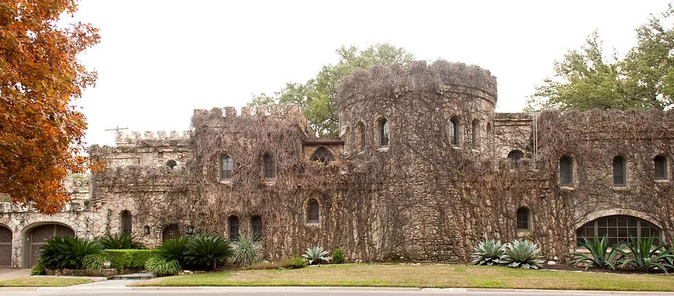
“Pemberton Heights sits upon a limestone shelf overlooking Shoal Creek, offering expansive views of downtown, the Capitol, and The University of Texas to the homes along the eastern edge of the community. The first house in the neighborhood was built in the late 1800s, but full-scale development of the area began in the 1920s.” More than 40 homes are designated as historic landmarks, including the Pemberton Castle which originated as a water tower used for fighting fires, then for watering crops on surrounding farms. Building two major bridges across Shoal Creek at Windsor/24th Street and also at 29th Street connected Pemberton Heights with the city center, making it one of the first Austin automobile suburbs in the 1920s.
Clara Driscoll Texas Historical Marker (2312 San Gabriel Street)
Clara Driscoll, businesswoman, philanthropist, and historic preservationist, was born in 1881, the daughter of Robert Driscoll who had amassed a multimillion-dollar empire in ranching, banking, and commercial developments centered in the Corpus Christi area. After almost a decade of study and travel abroad, Clara Driscoll returned to Texas at the age of eighteen and contributed over $70,000 to save and preserve the Alamo in San Antonio. She and her husband, Henry Hume (Hal) Servier, who founded the Austin American newspaper, built their home, Laguna Gloria, on a site originally selected by Stephen F. Austin for his homestead on the Colorado River near the city. Clara later presented Laguna Gloria to the Texas Fine Arts Association to create an art gallery. The mansion and its grounds were formerly the Austin Museum of Art and today are home of The Contemporary Austin. In 1939 she gave $92,000 to the Texas Federation of Women’s Clubs to allow the purchase of their Austin building at 24th and San Gabriel Streets, now the site of her historical marker in Austin.
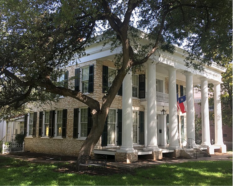
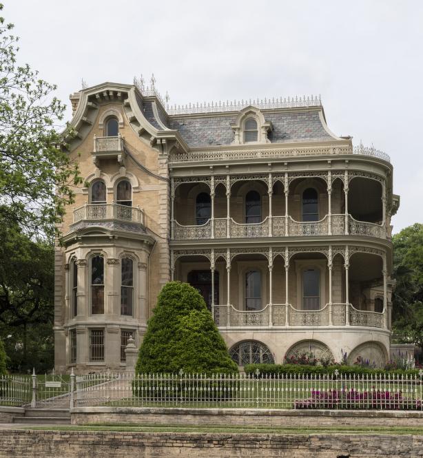
Neill-Cochran House (2310 San Gabriel Street)
The Neill-Cochran House was built in 1855 by the acclaimed architect Abner Cook, who also designed the Texas Governor’s Mansion, both in the Greek Revival style. It was leased to the Texas Institute for the Blind in 1856 and later to Lt. Governor Fletcher Stockdale. At the end of the Civil War, the home was provided to General George Armstrong Custer and his wife Libbie while stationed in Austin, and it served as the Union Army’s headquarters for the duration of Custer’s three-month stay. Custer’s troops camped along Shoal Creek in an area of Pease Park now known as Custer’s Meadow. Cholera swept through the camp, and the house was used as a hospital to care for the Federal troops. Those who succumbed to the illness were buried along Shoal Creek only to be disinterred by a flood in 1900. Today, the property is a historic house museum dedicated to the city’s history from its founding into the 20th century.
Austin Graded School / Pease Elementary School (1106 Rio Grande Street)
Pease Elementary School, originally the Austin Graded School House under the Austin Public Free Schools, was the first school in Austin built entirely from public funds and opened in 1876 – the same year Texas adopted its current constitution. In 1902, the school was renamed for former governor Elisha M. Pease. Before closing in 2020, it was the state’s longest continually operating public school.
Wooldridge Square (900 Guadalupe Street)
One of four public squares designated in the original plan for Austin in 1839 by Edwin Waller, Wooldridge Square, is home to a bandstand that has been used for political rallies, concerts, and celebrations for over 100 years. The Historical Marker was re-dedicated on May 12, 2023 with support from City leaders and Friends of Wooldridge Square.
Moonlight Towers (Various Locations, Historical Marker at Guadalupe & W 9th Street)
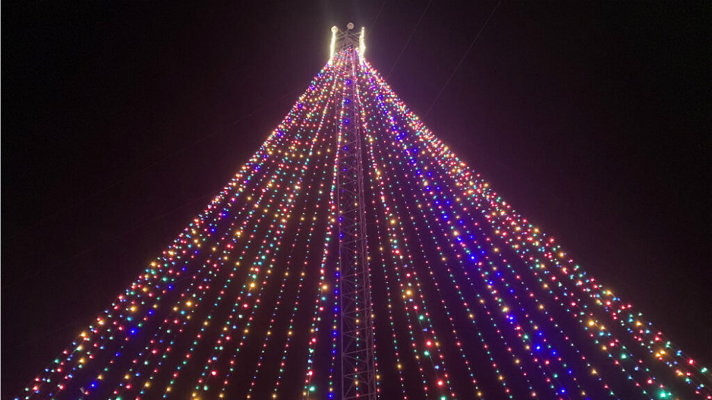
Austin’s iconic moonlight towers (or moon towers), purchased secondhand from the city of Detroit and erected in mostly residential areas throughout Austin in 1895, were 165-foot-tall truss structures containing six carbon arc lamps that illuminated the city at night, allowing residents to leave their homes after dark and showing many people electric light for the first time. Today, Austin’s moonlight towers are the only working moonlight towers in the world, and one serves as the centerpiece for the Zilker Holiday Tree each December.
Austin History Center (810 Guadalupe Street)
The local history division of the Austin Public Library, the Austin History Center collects and preserves information about institutions, businesses, residents, neighborhoods, and events of Austin and Travis County. The building itself is also historic, serving as Austin’s main public library from its opening in 1933 until 1979.
Bremond Block National Historic District (700 Guadalupe Street)
A collection of eleven well-preserved historic homes that housed successful merchants in the late 1800s, the Bremond Block Historic District is one of the few remaining upper-class Victorian neighborhoods in Texas and is listed on the National Register of Historic Places. Six homes were built or expanded for members of the families of brothers Eugene and John Bremond, who were prominent in late-nineteenth-century Austin social, merchandising, and banking circles. Standing out among the residences, the John Bremond House, constructed in 1886 by George Fiegel, features an ornate cast-iron wrap-around porch and balcony, as well as an eye-catching mansard roof.
Treaty Oak Square (507 Baylor Street)
Treaty Oak Square is a small park just large enough to contain Austin’s most famous tree, the 500-year-old Treaty Oak. This is the last survivor of fourteen live oaks, known as the Council Oaks, that is said to have been a sacred meeting place for Commanches and Tonkowas. Though proof is lacking, legend has it that Stephen F. Austin signed the first boundary agreement between the native people and the settlers in this grove of trees, providing the origin of its name. In 1927, the Treaty Oak was admitted to the American Forestry Association hall of Fame for Trees and declared the most perfect specimen of a North American tree. In 1937, the city of Austin purchased the land for $1,000 from the widow of W. H. Caldwell and installed a plaque honoring the tree‘s role in Texas history. The tree suffered intentional vandalism 1989 but, though almost two-thirds of the tree died, the Treaty Oak survived and has recovered well over the subsequent decades.
