Understanding Shoal Creek
October 24, 2019 | By Shoal Creek Conservancy
What are the major challenges facing the Shoal Creek watershed?
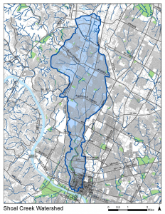 The highly urban character of the Shoal Creek Watershed presents special challenges and requires a multifaceted approach to addressing water-related issues. Increases in population density and the amount of impervious cover result in more frequent flooding, degradation of water quality, and loss of habitat and safe recreation areas. Although the Shoal Creek Watershed is only 13 square miles, its population is expected to reach over 78,000 by the year 2030 and 53% of the watershed is already surfaced in impervious cover. Moreover, the bulk of development in the Shoal Creek Watershed took place before the adoption of environmental protection regulations. Fifty-six percent of development in the watershed was built before the adoption of drainage regulations in 1974, and 71% was constructed before the adoption of water quality regulations in 1991. Finally, the watershed is slated for increased density and further redevelopment in the years to come, as the City of Austin overhauls its Land Development Code.
Water Quality: Once home to popular swimming and fishing destinations, the Creek suffers from poor water quality, including elevated fecal bacteria and nutrient levels. With impervious cover causing rapid stormwater runoff into Shoal Creek, nonpoint source pollution is a major challenge for the Shoal Creek Watershed. Human and canine fecal matter, fertilizer, sediment from erosion and construction sites, oil, grease, and other types of urban runoff all contribute to Shoal Creek’s pollution issue.
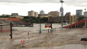
Flooding: The Shoal Creek Watershed is one of the City’s highest priorities for controlling and mitigating floods. In 1981, flooding killed 13 people and resulted in $35 million in damages. Several large floods, most notably in 1960, 1981, 2001 and 2013, have caused millions of dollars in damages to local businesses and homes. On Memorial Day weekend in 2015, rainstorms caused flow in the creek to grow from its average of 90 gallons per minute to 6 million gallons per minute. Flood waters again inundated roads, homes and businesses and necessitated dozens of rescues. Read this blog post to learn more about Shoal Creek flooding and how to stay safe during and after a flood.
Erosion & Habitat Loss: Because the watershed is highly developed, stormwater flows quickly over the landscape, and in addition to carrying pollutants, causes significant erosion and destabilization of creek and tributary banks. Erosion is one of the primary causes of native habitat loss on Shoal Creek. Sediment also worsens water quality conditions, limits recreation and creates safety hazards. According to a citywide inventory of citizen-reported erosion sites, the Shoal Creek Watershed accounts for 14% of the erosion site problem scores, the largest portion of total scores represented by any single watershed.
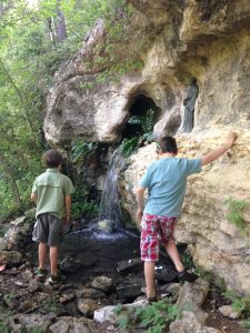
Groundwater & Spring Flow: The Shoal Creek Watershed is home to numerous springs, including at its headwaters, that suffer from reduced flow or have ceased flowing altogether. Diminished spring flow poses a serious threat to both the watershed’s overall ecosystem as well as regional water supply. Three and a half square miles of the Shoal Creek Watershed recharge the Edwards Aquifer, which provides drinking water to many Central Texas residents and sustains native Hill Country habitats. Reduced flows can exacerbate the effects of pollution, impacting the quality of water in the creek for wildlife, recreation, and ultimately drinking water. Spring flows also provide critical instream flows for local and regional species.